17
views
0
recommends
+1 Recommend
0 collections
    0
    shares
      • Record: found
      • Abstract: found
      • Article: found
      Is Open Access

      Geospatial clustering and correlates of deaths during the Ebola outbreak in Liberia: a Bayesian geoadditive semiparametric analysis of nationally representative cross-sectional survey data

      research-article
      ,
      BMJ Open
      BMJ Publishing Group
      public health, epidemiology, geographical mapping, demography

      Read this article at

      Bookmark
          There is no author summary for this article yet. Authors can add summaries to their articles on ScienceOpen to make them more accessible to a non-specialist audience.

          Abstract

          Objective

          To investigate the extent of geospatial clustering of reported deaths during the Ebola outbreak in Liberia and the covariates associated with the observed clustering.

          Design

          Cross-sectional study.

          Participants

          Male and female respondents from the 2019–2020 Liberia Demographic and Health Survey. The analysis covered 11 928 (women=7854 and men=4074) respondents for whom complete data were available.

          Outcome measures

          The outcome variable was the death of a household member or relative during the Ebola outbreak in Liberia, coded 1 if the respondent reported death and 0 otherwise.

          Methods

          We applied the Bayesian geoadditive semiparametric regression to examine the extent of geospatial clustering of deaths at the district-level and community-level development and socioeconomic factors associated with the observed clustering.

          Results

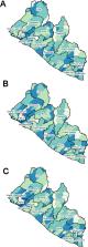
          Almost a quarter (24.8%) of all respondents reported the death of a household member or relative during the Ebola outbreak. The results show that deaths were clustered within districts in six (Grand Cape Mount, Bomi, Monsterrado, Margibi, Gbarpolu and Lofa) of the 15 counties in Liberia. Districts with high death clustering were all near or shared borders with Sierra Leone and Guinea. The community-level development indicators (global human footprint, gross cell production and population density) had a non-linear associative effect with the observed spatial clustering. Also, respondents’ characteristics (respondent’s age (non-linear effect), educational attainment and urban-rural place of residence) were associated with the observed clustering. The results show that death clustering during outbreaks was constrained to poor settings and impacts areas of moderate and high socioeconomic development.

          Conclusion

          Reported deaths during the Ebola outbreak in Liberia were not randomly distributed at the district level but clustered. The findings highlight the need to identify at-risk populations during epidemics and respond with the needed interventions to save lives.

          Related collections

          Most cited references41

          • Record: found
          • Abstract: found
          • Article: found
          Is Open Access

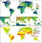
          Sixteen years of change in the global terrestrial human footprint and implications for biodiversity conservation

          Human pressures on the environment are changing spatially and temporally, with profound implications for the planet's biodiversity and human economies. Here we use recently available data on infrastructure, land cover and human access into natural areas to construct a globally standardized measure of the cumulative human footprint on the terrestrial environment at 1 km2 resolution from 1993 to 2009. We note that while the human population has increased by 23% and the world economy has grown 153%, the human footprint has increased by just 9%. Still, 75% the planet's land surface is experiencing measurable human pressures. Moreover, pressures are perversely intense, widespread and rapidly intensifying in places with high biodiversity. Encouragingly, we discover decreases in environmental pressures in the wealthiest countries and those with strong control of corruption. Clearly the human footprint on Earth is changing, yet there are still opportunities for conservation gains.
            Bookmark
            • Record: found
            • Abstract: not found
            • Article: not found

            Methods to account for spatial autocorrelation in the analysis of species distributional data: a review

              Bookmark
              • Record: found
              • Abstract: found
              • Article: found
              Is Open Access

              Population Distribution, Settlement Patterns and Accessibility across Africa in 2010

              The spatial distribution of populations and settlements across a country and their interconnectivity and accessibility from urban areas are important for delivering healthcare, distributing resources and economic development. However, existing spatially explicit population data across Africa are generally based on outdated, low resolution input demographic data, and provide insufficient detail to quantify rural settlement patterns and, thus, accurately measure population concentration and accessibility. Here we outline approaches to developing a new high resolution population distribution dataset for Africa and analyse rural accessibility to population centers. Contemporary population count data were combined with detailed satellite-derived settlement extents to map population distributions across Africa at a finer spatial resolution than ever before. Substantial heterogeneity in settlement patterns, population concentration and spatial accessibility to major population centres is exhibited across the continent. In Africa, 90% of the population is concentrated in less than 21% of the land surface and the average per-person travel time to settlements of more than 50,000 inhabitants is around 3.5 hours, with Central and East Africa displaying the longest average travel times. The analyses highlight large inequities in access, the isolation of many rural populations and the challenges that exist between countries and regions in providing access to services. The datasets presented are freely available as part of the AfriPop project, providing an evidence base for guiding strategic decisions.
                Bookmark

                Author and article information

                Journal
                BMJ Open
                BMJ Open
                bmjopen
                bmjopen
                BMJ Open
                BMJ Publishing Group (BMA House, Tavistock Square, London, WC1H 9JR )
                2044-6055
                2022
                27 June 2022
                : 12
                : 6
                : e054095
                Affiliations
                [1]departmentDepartment of Population and Health, Faculty of Social Sciences, College of Humanities and Legal Studies , University of Cape Coast , Cape Coast, Ghana
                Author notes
                [Correspondence to ] Professor Fiifi Amoako Johnson; famoakojohnson@ 123456ucc.edu.gh
                Author information
                http://orcid.org/0000-0003-0896-937X
                Article
                bmjopen-2021-054095
                10.1136/bmjopen-2021-054095
                9237885
                35760547
                1472c420-e1b4-4896-a3e9-85f5fc5418d5
                © Author(s) (or their employer(s)) 2022. Re-use permitted under CC BY-NC. No commercial re-use. See rights and permissions. Published by BMJ.

                This is an open access article distributed in accordance with the Creative Commons Attribution Non Commercial (CC BY-NC 4.0) license, which permits others to distribute, remix, adapt, build upon this work non-commercially, and license their derivative works on different terms, provided the original work is properly cited, appropriate credit is given, any changes made indicated, and the use is non-commercial. See:  http://creativecommons.org/licenses/by-nc/4.0/.

                History
                : 16 June 2021
                : 17 June 2022
                Categories
                Epidemiology
                1506
                1692
                Original research
                Custom metadata
                unlocked

                Medicine
                public health,epidemiology,geographical mapping,demography
                Medicine
                public health, epidemiology, geographical mapping, demography

                Comments

                Comment on this article