3
views
0
recommends
+1 Recommend
0 collections
    0
    shares
      • Record: found
      • Abstract: found
      • Article: found
      Is Open Access

      GLOBathy, the global lakes bathymetry dataset

      data-paper

      Read this article at

      Bookmark
          There is no author summary for this article yet. Authors can add summaries to their articles on ScienceOpen to make them more accessible to a non-specialist audience.

          Abstract

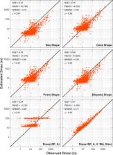
          Waterbodies (natural lakes and reservoirs) are a critical part of a watershed’s ecological and hydrological balance, and in many cases dictate the downstream river flows either through natural attenuation or through managed controls. Investigating waterbody dynamics relies primarily on understanding their morphology and geophysical characteristics that are primarily defined by bathymetry. Bathymetric conditions define stage-storage relationships and circulation/transport processes in waterbodies. Yet many studies oversimplify these mechanisms due to unavailability of the bathymetric data. We developed a novel GLObal Bathymetric (GLOBathy) dataset of 1.4+ million waterbodies to align with the well-established global dataset, HydroLAKES. GLOBathy uses a GIS-based framework to generate bathymetric maps based on the waterbody maximum depth estimates and HydroLAKES geometric/geophysical attributes of the waterbodies. The maximum depth estimates are validated at 1,503 waterbodies, making use of several observed data sources. We also provide estimations for head-Area-Volume ( h-A-V) relationships of the HydroLAKES waterbodies, driven from the bathymetric maps of the GLOBathy dataset. The h-A-V relationships provide essential information for water balance and hydrological studies of global waterbody systems.

          Abstract

          Measurement(s) lake depth • reservoir depth • bathymetry • Head-Area-Volume relationship
          Technology Type(s) machine learning • Geographic Information System • bathymetry data processing
          Sample Characteristic - Environment water body
          Sample Characteristic - Location global

          Machine-accessible metadata file describing the reported data: 10.6084/m9.figshare.16695070

          Related collections

          Most cited references36

          • Record: found
          • Abstract: not found
          • Article: not found

          Random Forests

            Bookmark
            • Record: found
            • Abstract: not found
            • Article: not found

            The Shuttle Radar Topography Mission

              Bookmark
              • Record: found
              • Abstract: not found
              • Article: not found

              Global river hydrography and network routing: baseline data and new approaches to study the world's large river systems

                Bookmark

                Author and article information

                Contributors
                bkhazaei@ucar.edu
                Journal
                Sci Data
                Sci Data
                Scientific Data
                Nature Publishing Group UK (London )
                2052-4463
                3 February 2022
                3 February 2022
                2022
                : 9
                : 36
                Affiliations
                GRID grid.57828.30, ISNI 0000 0004 0637 9680, Research Applications Laboratory, , National Center for Atmospheric Research, ; Boulder, CO 80301 USA
                Author information
                http://orcid.org/0000-0002-1222-9975
                http://orcid.org/0000-0002-5537-7775
                http://orcid.org/0000-0002-0688-3460
                Article
                1132
                10.1038/s41597-022-01132-9
                8814159
                35115560
                19aa1ee5-e387-4aee-8a34-cdad92d53876
                © The Author(s) 2022

                Open Access This article is licensed under a Creative Commons Attribution 4.0 International License, which permits use, sharing, adaptation, distribution and reproduction in any medium or format, as long as you give appropriate credit to the original author(s) and the source, provide a link to the Creative Commons license, and indicate if changes were made. The images or other third party material in this article are included in the article’s Creative Commons license, unless indicated otherwise in a credit line to the material. If material is not included in the article’s Creative Commons license and your intended use is not permitted by statutory regulation or exceeds the permitted use, you will need to obtain permission directly from the copyright holder. To view a copy of this license, visit http://creativecommons.org/licenses/by/4.0/.

                The Creative Commons Public Domain Dedication waiver http://creativecommons.org/publicdomain/zero/1.0/ applies to the metadata files associated with this article.

                History
                : 5 January 2021
                : 21 December 2021
                Funding
                Funded by: FundRef https://doi.org/10.13039/100000192, United States Department of Commerce | National Oceanic and Atmospheric Administration (NOAA);
                Award ID: NA18OAR4590363
                Award ID: NA18OAR4590363
                Award ID: NA18OAR4590363
                Award ID: NA18OAR4590363
                Award ID: NA18OAR4590363
                Award Recipient :
                Categories
                Data Descriptor
                Custom metadata
                © The Author(s) 2022

                limnology,hydrology,geophysics,geomorphology,civil engineering

                Comments

                Comment on this article