48
views
0
recommends
+1 Recommend
0 collections
    0
    shares
      • Record: found
      • Abstract: found
      • Article: found
      Is Open Access

      The nexus between forest fragmentation in Africa and Ebola virus disease outbreaks

      research-article

      Read this article at

      Bookmark
          There is no author summary for this article yet. Authors can add summaries to their articles on ScienceOpen to make them more accessible to a non-specialist audience.

          Abstract

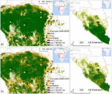
          Tropical forests are undergoing land use change in many regions of the world, including the African continent. Human populations living close to forest margins fragmented and disturbed by deforestation may be particularly exposed to zoonotic infections because of the higher likelihood for humans to be in contact with disease reservoirs. Quantitative analysis of the nexus between deforestation and the emergence of Ebola virus disease (EVD), however, is still missing. Here we use land cover change data in conjunction with EVD outbreak records to investigate the association between recent (2004–2014) outbreaks in West and Central Africa, and patterns of land use change in the region. We show how in these EVD outbreaks the index cases in humans (i.e. spillover from wildlife reservoirs) occurred mostly in hotspots of forest fragmentation.

          Related collections

          Most cited references26

          • Record: found
          • Abstract: not found
          • Article: not found

          The Analysis of Spatial Association by Use of Distance Statistics

            Bookmark
            • Record: found
            • Abstract: found
            • Article: found
            Is Open Access

            Filoviruses in Bats: Current Knowledge and Future Directions

            Filoviruses, including Ebolavirus and Marburgvirus, pose significant threats to public health and species conservation by causing hemorrhagic fever outbreaks with high mortality rates. Since the first outbreak in 1967, their origins, natural history, and ecology remained elusive until recent studies linked them through molecular, serological, and virological studies to bats. We review the ecology, epidemiology, and natural history of these systems, drawing on examples from other bat-borne zoonoses, and highlight key areas for future research. We compare and contrast results from ecological and virological studies of bats and filoviruses with those of other systems. We also highlight how advanced methods, such as more recent serological assays, can be interlinked with flexible statistical methods and experimental studies to inform the field studies necessary to understand filovirus persistence in wildlife populations and cross-species transmission leading to outbreaks. We highlight the need for a more unified, global surveillance strategy for filoviruses in wildlife, and advocate for more integrated, multi-disciplinary approaches to understand dynamics in bat populations to ultimately mitigate or prevent potentially devastating disease outbreaks.
              Bookmark
              • Record: found
              • Abstract: found
              • Article: not found

              Mapping global cropland and field size.

              A new 1 km global IIASA-IFPRI cropland percentage map for the baseline year 2005 has been developed which integrates a number of individual cropland maps at global to regional to national scales. The individual map products include existing global land cover maps such as GlobCover 2005 and MODIS v.5, regional maps such as AFRICOVER and national maps from mapping agencies and other organizations. The different products are ranked at the national level using crowdsourced data from Geo-Wiki to create a map that reflects the likelihood of cropland. Calibration with national and subnational crop statistics was then undertaken to distribute the cropland within each country and subnational unit. The new IIASA-IFPRI cropland product has been validated using very high-resolution satellite imagery via Geo-Wiki and has an overall accuracy of 82.4%. It has also been compared with the EarthStat cropland product and shows a lower root mean square error on an independent data set collected from Geo-Wiki. The first ever global field size map was produced at the same resolution as the IIASA-IFPRI cropland map based on interpolation of field size data collected via a Geo-Wiki crowdsourcing campaign. A validation exercise of the global field size map revealed satisfactory agreement with control data, particularly given the relatively modest size of the field size data set used to create the map. Both are critical inputs to global agricultural monitoring in the frame of GEOGLAM and will serve the global land modelling and integrated assessment community, in particular for improving land use models that require baseline cropland information. These products are freely available for downloading from the http://cropland.geo-wiki.org website.
                Bookmark

                Author and article information

                Journal
                Sci Rep
                Sci Rep
                Scientific Reports
                Nature Publishing Group
                2045-2322
                14 February 2017
                2017
                : 7
                : 41613
                Affiliations
                [1 ]Department of Civil and Environmental Engineering, Politecnico di Milano , Milan, Italy
                [2 ]Division on Impacts on Agriculture, Forests and Ecosystem Services, Fondazione Centro Euro-Mediterraneo sui Cambiamenti Climatici , Viterbo, Italy
                [3 ]Molecular Epidemiology and Public Health Laboratory (mEpiLab), Hopkirk Research Institute, Massey University, Private Bag 11 222 , Palmerston North 4442, New Zealand
                [4 ]Department of Environmental Sciences, University of Virginia , Charlottesville, VA, USA
                [5 ]Department of Environmental Science, Policy and Management, University of California , Berkeley, CA, USA
                [6 ]National Social Environmental Synthesis Center, University of Maryland , Annapolis, MD, USA
                Author notes
                Article
                srep41613
                10.1038/srep41613
                5307336
                28195145
                3d4a3809-95c8-49df-bbb1-3bd0b85a8249
                Copyright © 2017, The Author(s)

                This work is licensed under a Creative Commons Attribution 4.0 International License. The images or other third party material in this article are included in the article’s Creative Commons license, unless indicated otherwise in the credit line; if the material is not included under the Creative Commons license, users will need to obtain permission from the license holder to reproduce the material. To view a copy of this license, visit http://creativecommons.org/licenses/by/4.0/

                History
                : 17 August 2016
                : 22 December 2016
                Categories
                Article

                Uncategorized
                Uncategorized

                Comments

                Comment on this article